

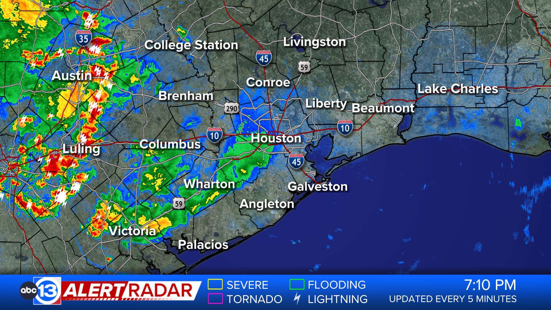
ABC13 Houston Weather Radar for Southeast Texas

- Flood Watch
Several days of storms have primed soils across the area, particularly near Matagorda Bay, which saw particularly heavy rainfall Thursday morning. More storms are expected to form today, with a particular focus near the Gulf coast. Lower on the coast, nearer Matagorda Bay, previous heavy rainfall and flooding means that rainfall will convert to runoff and potential flooding very easily. Farther up the coast, especially east of Galveston Bay, today's storms may produce very heavy rainfall, creating a flooding threat there as well. * WHAT...Flooding caused by excessive rainfall continues to be possible. * WHERE...A portion of southeast Texas, including the following areas, Bolivar Peninsula, Chambers, Coastal Galveston, Coastal Harris, Galveston Island, Inland Galveston and Southern Liberty. * WHEN...Through this evening. * IMPACTS...Excessive runoff may result in flooding of rivers, creeks, streams, and other low-lying and flood-prone locations. Flooding may occur in poor drainage and urban areas. * ADDITIONAL DETAILS... - http://www.weather.gov/safety/floodMore
- Flood Warning
* WHAT...Flooding caused by excessive rainfall earlier Thursday. * WHERE...Portions of south central and southeast Texas, including the following counties, in south central Texas, Jackson. In southeast Texas, Matagorda. * WHEN...Until 700 AM CDT Friday. * IMPACTS...Drivetexas.org indicates some roads remain closed due to flooding across portions of the warned area. It will take several hours for all the water from these storms to gradually recede off roadways. * ADDITIONAL DETAILS... - At 920 PM CDT, Heavy rain on Thursday produced a swath of 6 to 10 plus inches of rainfall. - Most areas will see a break in precipitation into the overnight hours followed by possible redevelopment of some scattered showers and thunderstorms just prior to sunrise. Additional rain amounts up to 0.5 inches are possible in the warned area. - Some locations that will experience flooding include... Palacios, La Ward, Lolita, Blessing, Lake Texana Dam, Vanderbilt and Midfield. - http://www.weather.gov/safety/floodMore
- Flood Warning
...The Flood Warning continues for the following rivers in Texas... Trinity River at Liberty affecting Liberty County. Tres Palacios River near Midfield affecting Wharton and Matagorda Counties. Trinity River at Riverside affecting Trinity, Polk, Walker and San Jacinto Counties. Trinity River near Moss Bluff affecting Liberty and Chambers Counties. San Bernard River near Boling affecting Wharton, Brazoria and Fort Bend Counties. For the Trinity River...including Crockett, Riverside, Romayor, Goodrich, Moss Bluff, Liberty...Minor flooding is forecast. For the Tres Palacios River...including Midfield...Moderate flooding is forecast. * WHAT...Minor flooding is occurring and minor flooding is forecast. * WHERE...Trinity River at Liberty. * WHEN...Until early Sunday morning. * IMPACTS...At 26.5 feet, Roads into some outlying communities above the gage can have up to one foot of water over them. * ADDITIONAL DETAILS... - At 8:15 PM CDT Thursday the stage was 26.4 feet. - Bankfull stage is 21.0 feet. - Recent Activity...The maximum river stage in the 24 hours ending at 8:15 PM CDT Thursday was 26.5 feet. - Forecast...The river is expected to fall below flood stage early Saturday afternoon and continue falling to 25.5 feet Tuesday evening. - Flood stage is 26.0 feet. - Flood History...This crest compares to a previous crest of 26.5 feet on 12/31/2001. - http://www.weather.gov/safety/floodMore
- Flood Warning
...The Flood Warning continues for the following rivers in Texas... Trinity River at Liberty affecting Liberty County. Tres Palacios River near Midfield affecting Wharton and Matagorda Counties. Trinity River at Riverside affecting Trinity, Polk, Walker and San Jacinto Counties. Trinity River near Moss Bluff affecting Liberty and Chambers Counties. San Bernard River near Boling affecting Wharton, Brazoria and Fort Bend Counties. For the Trinity River...including Crockett, Riverside, Romayor, Goodrich, Moss Bluff, Liberty...Minor flooding is forecast. For the Tres Palacios River...including Midfield...Moderate flooding is forecast. * WHAT...Minor flooding is occurring and minor flooding is forecast. * WHERE...Trinity River near Moss Bluff. * WHEN...Until further notice. * IMPACTS...At 15.2 feet, Moderate lowland flooding begins in the vicinity of the gage. * ADDITIONAL DETAILS... - At 8:30 PM CDT Thursday the stage was 13.8 feet. - Bankfull stage is 9.2 feet. - Recent Activity...The maximum river stage in the 24 hours ending at 8:30 PM CDT Thursday was 13.8 feet. - Forecast...The river is expected to rise to a crest of 13.8 feet just after midnight tonight. - Flood stage is 12.2 feet. - Flood History...This crest compares to a previous crest of 13.8 feet on 11/18/1998. - http://www.weather.gov/safety/floodMore


